
Idaho State Spotlight -Idaho Highway 21
Winter 2021
Barry L. Crose, Idaho Regional Director
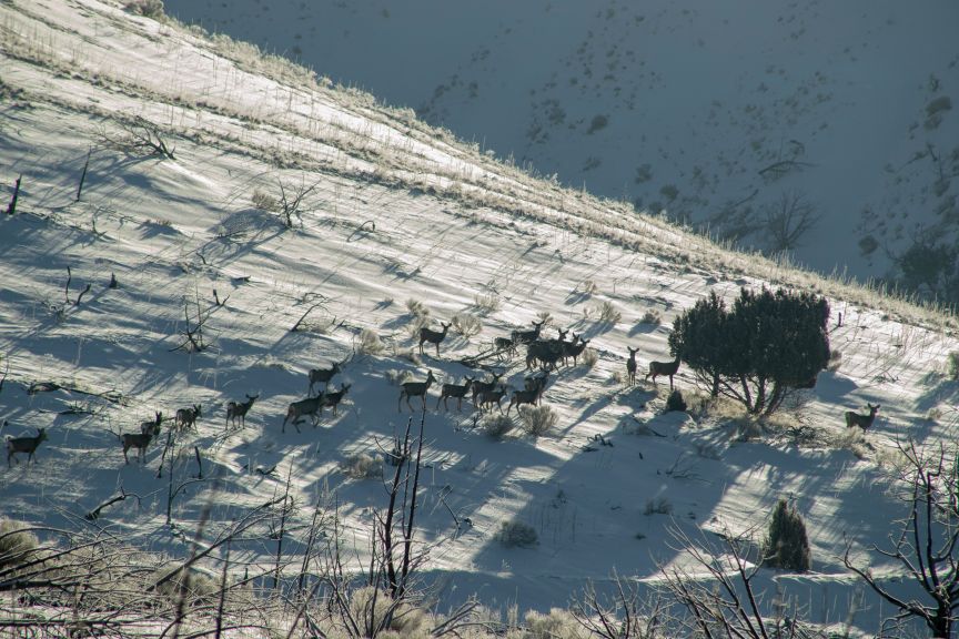
Back in my 2018 State Spotlight I wrote about the underpass that was constructed in the Boise Wildlife Management Area under Idaho Highway 21 at MP 18.2. The Boise River Wildlife Management Area (BRWMA) is a 47,000-acre wildlife preserve that is located east of and adjacent to the City of Boise. The BRWMA surrounds SH-21 and Lucky Peak Lake and is a primary day-use recreation destination. SH-21 directly supports the BRWMA and the City of Boise’s Ridge to Rivers overall trail system (which includes the BRWMA) providing access to a minimum of 30,000 users annually. As shown in the pictures with this article, deer and elk are using the underpass. Due to the continued high migration of animals across Highway 21, an overpass will be constructed a few miles north of the underpass at MP 19.32.
A recent economic analysis conducted in 2009, utilizing carcass data provided by Idaho Department of Fish and Game (IDFG), indicated that, on an annual basis, deer and elk collisions within the Idaho Highway 21 corridor from near MP 10 to MP 21 cost motorists and citizens of Idaho hundreds of thousands of dollars or more (source Rocky Mountain Econometrics, 2009). The costs of traffic colliding with wildlife on SH-21 from MP 17.4 to MP 20.4 was documented at over $3 million in costs to Idahoans, based on a 30+ year time interval from 1979 to 2010. It is estimated that during the summer weekends, Idaho Highway 21, has over 9,000 vehicles traveling daily; winter travel is estimated at 4,000 vehicles daily. Current data indicates that Winter 2021 provides access to a minimum of 30,000 trail users annually at 13 recreational pullouts/ parking areas, seven trail-heads, and two information/educational observation sites. In addition, Winter 2021 and the BRWMA directly and indirectly support sportsmen and hunters of southwest Idaho that utilize Game Management Unit (GMU) 39 for over 80,000 hunter days annually (the BRWMA lies entirely within GMU 39). Since the wildlife underpass was built at MP 18.2 and additional fencing phases have been completed, Idaho Transportation Department (ITD) crash data for Winter 2021 indicates only one reported vehicle-wildlife collision (VWC) between MP 17 to MP 18.
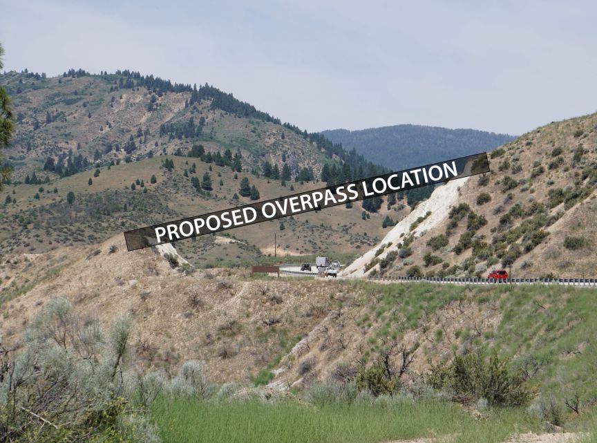
In conjunction with the previously built wildlife underpass at MP 18.2 and accompanying 8-ft exclusion fence, the proposed overpass would reduce VWCs by as much as 80 percent from MP 17.3 to MP 19.5 once completed to full build-out. The actual effects of an 80 percent reduction in VWCs could be extend- ed to approximately MP 20.4 with additional phases of fencing and/or mitigation prevention treatments. Critical habitat linkages for mule deer, elk, antelope, and other wildlife will be protected and enhanced for short and long-term perpetuity and for overall resource needs. Well established migratory and big game movement patterns will be retained and improved upon through additional permeability across the Winter 2021 travel corridor from MP 17.3 to MP 19.5 (i.e. afforded by the wildlife overpass). MP 19.32 was selected for the wildlife overpass based on historic data that indicates more elk are involved with VWCs between MP 18.5 through MP 20.4 than on other segments of SH-21.
This project directly relates to the Boise/Sawtooth National Forest (B/SNF) and their wildlife resource objectives of identifying and prioritizing opportunities for restoration of habitat linkage to promote genetic integrity and wildlife species distribution. The selected location for the overpass and accompanying big game exclusion fence will benefit and function to maintain in perpetuity a large migration/big game movement corridor utilized by a herd of 6,000 – 8,000 mule deer, 1,800 elk and hundreds of antelope. The referenced mule deer and elk are part of a larger herd of approximately 40,000 mule deer and 7,500 elk that respectively move between their summer ranges within the B/ SNF to their winter ranges within the Boise/Danskin/Bennett Mountain Fronts. Past IDFG radio-telemetry and GIS tracking data indicate some mule deer and elk traverse distances of over 60 to 70 miles from their summer ranges in the B/ SNF to the BRWMA to winter. The wildlife overpass and fencing would be located within federal and public land ownership and lie predominantly within the BRWMA where conservation of critical habitat linkages would be maintained.
The proposed wildlife overpass would be 150’ in length and would span 54’ to 66’ across Winter 2021. The overpass will have 18’ clearance from Idaho Highway 21 pavement to structure, with an overall 24.5’ proposed height. The structure would incorporate a Concrete Arch Design utilizing modular precast components and concrete footings. A waterproof geotextile would be placed over the entire concrete arch span to ensure a watertight structure. A span width of 54’ allows for a two-lane highway with minimum 5-ft shoulders that could act as bike lanes. A greater span width and arch height may reduce the amount of fill needs and account for future highway needs. Retaining walls, precast wingwalls or similar designs would be utilized on top and in conjunction with the concrete arch to help create the side flanged sections of the overpass as well as the earthen passageway for the overpass and are estimated to be 75’ or less for each side. Backfill consisting of native materials would be incorporated and compacted to create the natural earthen passage. An existing unimproved gravel access located on the north side of the wildlife overpass would be maintained and used for access and maintenance needs for the wildlife overpass and fencing needs.
This overpass will have 10 to 12 big game cameras to capture and observe big game usage. Four cameras will be installed on each end of the passage, consisting of one camera for each side and facing to- wards the middle and two cameras in the middle and facing outward to each side of the passage. Two cameras would be placed in the middle of the overpass passage and facing outward to each side of the passage (additional cameras could be in- stalled in the middle if needed).
Along with the overpass, big game exclusion fence will be located a minimum of 20-ft from the existing SH-21 fog line to insure clear-zone requirements are met; at locations where metal guardrail or concrete jersey-rail exists, fencing may be closer to the fog line as approved by the engineer but will be located behind such barriers. To account for recreational and view- shed needs, the project partners will work together for an appropriate alignment that can maintain adequate recreational opportunities and unobstructed views of the Mores Creek Arm of Lucky Peak Lake while ensuring SH-21 safety is accommodated. In some cases single-wire maintenance/access gates and one-way push gates will be utilized to maintain recreational opportunities. This fence will be 12,500 ft +/- of 8’ big game exclusion fence from approximately MP 18. 4/18.5 to MP 19.6. As with the underpass, this fence will help direct the animals to the overpass.
Estimated cost of the project is $2,977,392. Of this cost, $2,757,392 is requested from the Federal Lands Access program. Matching funds of $220,000 will be provided from the ITD, U.S. Forest Service, IDFG , and other partners.
As stated earlier in this article, once the project is completed an estimated 80 percent reduction (or possibly higher) in VWCs is achievable within the immediate vicinity of full build-out (i.e. from the Mores Creek High Bridge MP 17.2 to MP 19.6). This reduction in VWCs can be expanded to approximately MP 20.4 with additional phases of fencing and/or with other VWC preventative treatment measures implement- ed. The reduction in VWCs leads to reduced loss of property (i.e. lost vehicle usage), reduced insurance claims (i.e. lower auto/health/property insurance premiums), saves our wildlife resources (i.e. deer, elk and other wildlife), and reduces maintenance costs). It is conservatively estimated that this would save the public $100,000 or more annually. In addition, the reduction in VWCs creates an overall safer travel corridor for both motorists and wildlife. In the long run this project will pay for itself through these cost savings.
Other objectives that will be met include:
- Creating a safer travel corridor by providing safe passage opportunities for both motorists, big game, and other wildlife within the Idaho Highway 21 corridor as well as the BRW- MA, B/SNF, and other adjacent public lands.
- Reducing VWCs and carcasses on highways will help reduce injuries, loss of property, and potential loss of life.
- Fewer obstructions for both motorists and wildlife within the SH-21 travel corridor leads to greater mobility. Deer, elk, and other wildlife on a highway or even a road-killed carcass are potential obstructions and a risk to motorists mobility and their safety.
- Reduced maintenance costs and exposure to State of Idaho forces in retrieving/disposal of carcasses by minimizing the number of VWCs within the travel corridor. Every time State of Idaho forces are used to remove/dispose of carcasses, such an event places them in a compromised and dangerous situation, this project reduces those events.
The design of the project is anticipated to be late 2021 with construction starting in the summer of 2022. For additional information you can use this link: https://itdprojects.org/cervidaeoverpass


